Geolocate

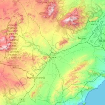
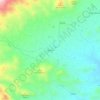
Lorca topographic map

Click on the map to display elevation.

Lorca

The town is situated at an elevation of 370 metres (1,200 ft) in eastern Spain between Granada and Murcia. It was part of the hura of Tidmir in the Muslim period when it became well known for its fertile soil and subsoil, and for its strategic location. It is situated on the southern slopes of the Siera del Cano mountains. The Guadalentín River flows through the town.

Wikipedia (CC-BY-SA 3.0)

About this map

Name: Lorca topographic map, elevation, terrain.

Location: Lorca, Alto Guadalentín, Region of Murcia, Spain (37.42102 -2.01265 37.96964 -1.39662)

Average elevation: 537 m

Minimum elevation: -1 m

Maximum elevation: 1,566 m

Other topographic maps

Click on a map to view its topography, its elevation and its terrain.
Henares

Spain > Region of Murcia > Alto Guadalentín > Lorca

Average elevation: 777 m

Girona

Spain > Region of Murcia > Alto Guadalentín > Lorca

Average elevation: 644 m

Churra

Spain > Region of Murcia > Alto Guadalentín > Lorca

Average elevation: 332 m

Xiquena

Spain > Region of Murcia > Alto Guadalentín > Lorca

Average elevation: 705 m

Morata

Spain > Region of Murcia > Alto Guadalentín > Lorca

Average elevation: 381 m

Gear up for your next adventure:

💧Hydration Pack - Hands-free hydration system for long hikes
🥾Light Trekking Boots - Supportive boots for multi-day treks
🥘Camping Cookware Set - Compact nesting pots and pans for trail cooking
🔥Camping Stove - Portable stoves to cook outdoors with ease
🧭Orienteering Kit - Tools for map reading and navigation in the wild

As an Amazon Associate, this site earns from qualifying purchases at no extra cost to you.