
Bidar topographic map
Click on the map to display elevation.
Bidar
Bidar is located at 17°54′N 77°30′E / 17.9°N 77.5°E / 17.9; 77.5, lies at a central position in Deccan, a plateau at an elevation of 2300 ft from the sea level. It has common boundaries with Maharashtra and Telangana which is, with the districts of Nizamabad and Medak in Telangana on the East and the districts of Latur, Nanded and Osmanabad in Maharashtra on the west. On the south lies the district Gulbarga of Karnataka.
About this map
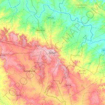
Name: Bidar topographic map, elevation, terrain.
Location: Bidar, Bidar taluku, Bidar, Karnataka, 585400, India (17.75438 77.36636 18.07438 77.68636)
Average elevation: 593 m
Minimum elevation: 520 m
Maximum elevation: 680 m