Geolocate

Valbondione topographic map

Click on the map to display elevation.

About this map

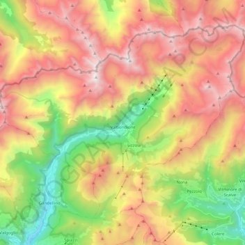
Name: Valbondione topographic map, elevation, terrain.

Location: Valbondione, Bergamo, Lombardy, Italy (45.98201 9.90646 46.09120 10.10445)

Average elevation: 1,825 m

Minimum elevation: 640 m

Maximum elevation: 3,038 m

Gear up for your next adventure:

🔋Emergency Crank Radio - Weather alerts and power without needing batteries
🧰Survival Kit - Essential gear for emergencies in the wilderness
🧣Evaporative Cooling Towel - Beat the heat during intense summer climbs
🧢Hiking Hat - Sun-protective and breathable hats for long treks
🛌Down Sleeping Bag - Superior warmth-to-weight ratio for cold nights

As an Amazon Associate, this site earns from qualifying purchases at no extra cost to you.