
Make a donation
Gear up for your next adventure:
As an Amazon Associate, this site earns from qualifying purchases at no extra cost to you.
Herresbach topographic map
Click on the map to display elevation.
Make a donation
Gear up for your next adventure:
As an Amazon Associate, this site earns from qualifying purchases at no extra cost to you.
About this map
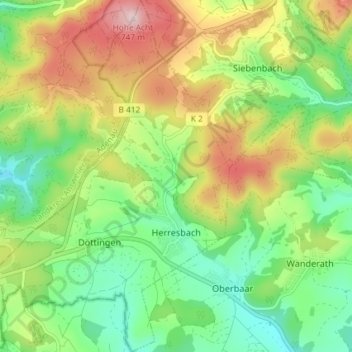
Name: Herresbach topographic map, elevation, terrain.
Average elevation: 536 m
Minimum elevation: 417 m
Maximum elevation: 717 m
Make a donation
Gear up for your next adventure:
As an Amazon Associate, this site earns from qualifying purchases at no extra cost to you.
Other topographic maps
Click on a map to view its topography, its elevation and its terrain.
Eltz Castle
Germany > Rhineland-Palatinate > Landkreis Mayen-Koblenz > Wierschem
Average elevation: 219 m
Miesenheim
Germany > Rhineland-Palatinate > Landkreis Mayen-Koblenz > Andernach
Average elevation: 120 m
Ettringer Bellberg
Germany > Rhineland-Palatinate > Landkreis Mayen-Koblenz > Ettringen
Average elevation: 342 m