Geolocate

Lajas topographic map

Click on the map to display elevation.

About this map

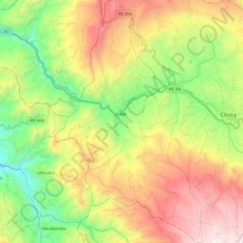
Name: Lajas topographic map, elevation, terrain.

Location: Lajas, Province of Chota, Cajamarca, Peru (-6.66141 -78.78667 -6.47228 -78.67121)

Average elevation: 2,588 m

Minimum elevation: 1,699 m

Maximum elevation: 3,754 m

Gear up for your next adventure:

🗺️Topographic Maps - Detailed maps to explore trails, mountains, and wilderness areas
🛏️Camping Sleeping Mat - Comfortable mats for sleeping outdoors
🧰Multitool Knife - Compact and versatile tool for outdoor use
🧤Rechargeable Heated Gloves - Extreme warmth for Canadian winter expeditions
🧭GPS Outdoor Watch - Smart watch for navigation and fitness tracking in nature

As an Amazon Associate, this site earns from qualifying purchases at no extra cost to you.