
Longhua District topographic map
Click on the map to display elevation.
About this map
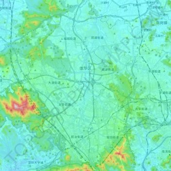
Name: Longhua District topographic map, elevation, terrain.
Location: Longhua District, Shenzhen, Guangdong, 518110, China (22.58399 113.96143 22.77460 114.10847)
Average elevation: 81 m
Minimum elevation: 11 m
Maximum elevation: 557 m
Other topographic maps
Click on a map to view its topography, its elevation and its terrain.
Mount Yangtai
The Mount Yangtai (Chinese: 羊台山; pinyin: Yángtaíshān), also known as Mount Yangtai Forest Park, is a mountain at the junction of Bao'an District and Nanshan District in Shenzhen, Guangdong, China. The peak is 587.3 metres (1,927 ft) in elevation, which is the highest peak in western Shenzhen. In 2008…
Average elevation: 287 m