
Make a donation
Gear up for your next adventure:
As an Amazon Associate, this site earns from qualifying purchases at no extra cost to you.
Carlsberg topographic map
Click on the map to display elevation.
Make a donation
Gear up for your next adventure:
As an Amazon Associate, this site earns from qualifying purchases at no extra cost to you.
Carlsberg
The municipality lies at the north edge of the Palatinate Forest between the Haardt range in the south and the Autobahn A 6 in the north in the Leiningerland at an elevation of 285 m above sea level. Carlsberg belongs to the Verbandsgemeinde of Leiningerland, whose seat is in Grünstadt.
Make a donation
Gear up for your next adventure:
As an Amazon Associate, this site earns from qualifying purchases at no extra cost to you.
About this map
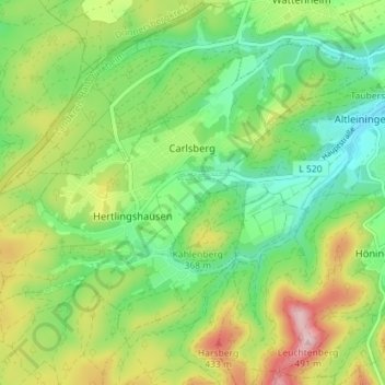
Name: Carlsberg topographic map, elevation, terrain.
Average elevation: 327 m
Minimum elevation: 238 m
Maximum elevation: 476 m
Make a donation
Gear up for your next adventure:
As an Amazon Associate, this site earns from qualifying purchases at no extra cost to you.
Other topographic maps
Click on a map to view its topography, its elevation and its terrain.