
Make a donation
Gear up for your next adventure:
As an Amazon Associate, this site earns from qualifying purchases at no extra cost to you.
Penida Island topographic map
Click on the map to display elevation.
Make a donation
Gear up for your next adventure:
As an Amazon Associate, this site earns from qualifying purchases at no extra cost to you.
Penida Island
Nusa Penida (Indonesian pronunciation: [nuˈsa pəˈnida]; Balinese: ᬦᬸᬲᬧᭂᬦᬶᬤ, romanized: nusa pĕnida) is an island located near the southeastern Indonesian island of Bali, which forms a district of the same name in Klungkung Regency. The Badung Strait separates the island and Bali. The interior of Nusa Penida is hilly with a maximum altitude of 524 metres, and the climate is drier than Bali. Like Bali, it is a major tourist destination.
Make a donation
Gear up for your next adventure:
As an Amazon Associate, this site earns from qualifying purchases at no extra cost to you.
About this map
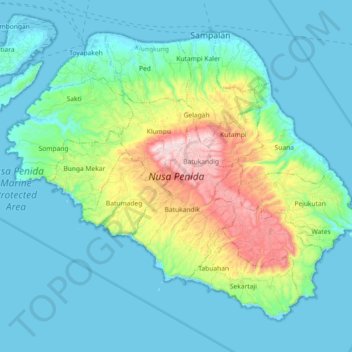
Name: Penida Island topographic map, elevation, terrain.
Average elevation: 104 m
Minimum elevation: -4 m
Maximum elevation: 517 m
Make a donation
Gear up for your next adventure:
As an Amazon Associate, this site earns from qualifying purchases at no extra cost to you.