Geolocate

Munger topographic map

Click on the map to display elevation.

About this map

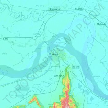
Name: Munger topographic map, elevation, terrain.

Location: Munger, Bihar, India (25.21735 86.31310 25.53735 86.63310)

Average elevation: 44 m

Minimum elevation: 27 m

Maximum elevation: 355 m

Gear up for your next adventure:

🧢Hiking Hat - Sun-protective and breathable hats for long treks
💡LED Headlamp - Hands-free illumination for night hiking and camping
🧥Thermal Layer - Insulating layer for cold outdoor conditions
Bushcraft Tarp - Versatile emergency shelter or gear protection
🧤Insulated Winter Gloves - Heavy-duty protection for sub-zero Canadian adventures

As an Amazon Associate, this site earns from qualifying purchases at no extra cost to you.