
Make a donation
Gear up for your next adventure:
As an Amazon Associate, this site earns from qualifying purchases at no extra cost to you.
Relizane topographic map
Click on the map to display elevation.
Make a donation
Gear up for your next adventure:
As an Amazon Associate, this site earns from qualifying purchases at no extra cost to you.
Relizane
The topography within 2 miles of Relizane is only modest variations in elevation, with a maximum elevation change of 210 feet and an average elevation above sea level of 230 feet. Within 16 kilometers, slight variations in altitude only (533 meters). Within 80 kilometers, very significant variations in altitude (1,268 meters).
Make a donation
Gear up for your next adventure:
As an Amazon Associate, this site earns from qualifying purchases at no extra cost to you.
About this map
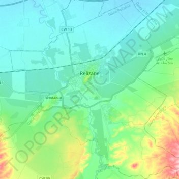
Name: Relizane topographic map, elevation, terrain.
Location: Relizane, Relizane District, Relizane, Algeria (35.65608 0.47790 35.79489 0.64835)
Average elevation: 92 m
Minimum elevation: 49 m
Maximum elevation: 250 m
Make a donation
Gear up for your next adventure:
As an Amazon Associate, this site earns from qualifying purchases at no extra cost to you.