
Make a donation
Gear up for your next adventure:
As an Amazon Associate, this site earns from qualifying purchases at no extra cost to you.
Jarabacoa topographic map
Click on the map to display elevation.
Make a donation
Gear up for your next adventure:
As an Amazon Associate, this site earns from qualifying purchases at no extra cost to you.
Jarabacoa
Jarabacoa has a Tropical rainforest climate (Köppen climate classification Af ). Due to its high elevation in the interior it has warm days and lower temperatures at nights during most of the year, and temperate days and colder nights during winter months. Because of its climate, visitors have christened Jarabacoa as "The City of Everlasting Spring." Rain is abundant during most all the year.
Make a donation
Gear up for your next adventure:
As an Amazon Associate, this site earns from qualifying purchases at no extra cost to you.
About this map
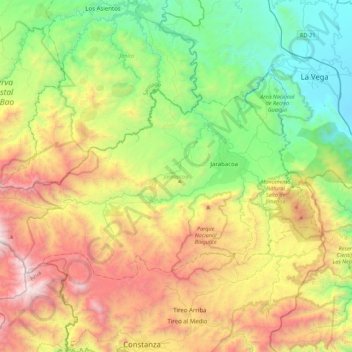
Name: Jarabacoa topographic map, elevation, terrain.
Location: Jarabacoa, La Vega, 41200, Dominican Republic (18.98326 -70.96021 19.22863 -70.51935)
Average elevation: 947 m
Minimum elevation: 67 m
Maximum elevation: 2,426 m
Make a donation
Gear up for your next adventure:
As an Amazon Associate, this site earns from qualifying purchases at no extra cost to you.
Other topographic maps
Click on a map to view its topography, its elevation and its terrain.