Geolocate

Slatina topographic map

Click on the map to display elevation.

About this map

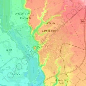
Name: Slatina topographic map, elevation, terrain.

Location: Slatina, Olt, Romania (44.38963 24.32058 44.47796 24.43349)

Average elevation: 148 m

Minimum elevation: 98 m

Maximum elevation: 210 m

Other topographic maps

Click on a map to view its topography, its elevation and its terrain.

Dejești

Romania > Olt

Average elevation: 297 m

Trepteni

Romania > Olt

Average elevation: 296 m

Proaspeți

Romania > Olt

Average elevation: 139 m

Băleasa

Romania > Olt

Average elevation: 175 m

Mărgăritești

Romania > Olt

Average elevation: 134 m

Simniceni

Romania > Olt

Average elevation: 199 m

Bistrița Nouă

Romania > Olt > Piatra-Olt

Average elevation: 156 m

Piscani

Romania > Olt > Scornicești

Average elevation: 225 m

Broșteni

Romania > Olt

Average elevation: 177 m

Mardale

Romania > Olt

Average elevation: 186 m

Dăneasa

Romania > Olt > Dăneasa

Average elevation: 90 m

Vitomirești

Romania > Olt > Vitomirești

Average elevation: 363 m

Deveselu

Romania > Olt > Deveselu

Average elevation: 98 m

Gear up for your next adventure:

🧥Packable Rain Jacket - Breathable waterproof layer for unpredictable weather
Lightweight Backpacking Tent - Compact tent for efficient hiking trips
🧥Softshell Hiking Jacket - The perfect balance of wind protection and breathability
🪑Insulated Seat Pad - Protect your seat from cold rocks and wet logs
🦯Trekking Poles - Reduced impact on joints for steep topographic climbs

As an Amazon Associate, this site earns from qualifying purchases at no extra cost to you.