Geolocate

İzmir topographic map

Click on the map to display elevation.

About this map

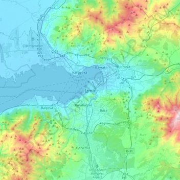
Name: İzmir topographic map, elevation, terrain.

Location: İzmir, Konak, Izmir, Aegean Region, 35250, Turkey (38.25925 26.96847 38.57925 27.28847)

Average elevation: 263 m

Minimum elevation: -4 m

Maximum elevation: 1,241 m

Gear up for your next adventure:

🔥Emergency Fire Starter - Reliable ignition source for all weather conditions
🥾Approach Boots - Comfortable boots for hiking and climbing approaches
🥾Hiking Leggings - Comfortable leggings for outdoor activities
🧰Multitool Knife - Compact and versatile tool for outdoor use
🧦Outdoor Socks - Durable socks designed for hiking and outdoor sports

As an Amazon Associate, this site earns from qualifying purchases at no extra cost to you.