
Make a donation
Gear up for your next adventure:
As an Amazon Associate, this site earns from qualifying purchases at no extra cost to you.
Parroquia Barceloneta topographic map
Click on the map to display elevation.
Make a donation
Gear up for your next adventure:
As an Amazon Associate, this site earns from qualifying purchases at no extra cost to you.
About this map
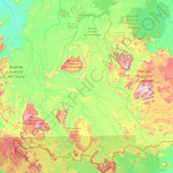
Name: Parroquia Barceloneta topographic map, elevation, terrain.
Average elevation: 541 m
Minimum elevation: 25 m
Maximum elevation: 2,632 m
Make a donation
Gear up for your next adventure:
As an Amazon Associate, this site earns from qualifying purchases at no extra cost to you.
Other topographic maps
Click on a map to view its topography, its elevation and its terrain.
Guiana Highlands
Venezuela > Bolivar State > Municipio Angostura
The Guiana Shield (French: Plateau des Guyanes, Bouclier guyanais; Dutch: Hoogland van Guyana, Guianaschild; Portuguese: Planalto das Guianas, Escudo das Guianas; Spanish: Escudo guayanés) is one of the three cratons of the South American Plate. It is a 1.7 billion-year-old Precambrian geological formation in…
Average elevation: 524 m