
Make a donation
Gear up for your next adventure:
As an Amazon Associate, this site earns from qualifying purchases at no extra cost to you.
Gnarrenburg topographic map
Click on the map to display elevation.
Make a donation
Gear up for your next adventure:
As an Amazon Associate, this site earns from qualifying purchases at no extra cost to you.
About this map
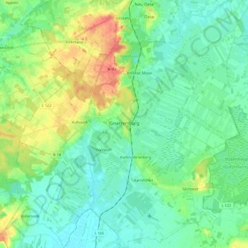
Name: Gnarrenburg topographic map, elevation, terrain.
Average elevation: 15 m
Minimum elevation: 1 m
Maximum elevation: 47 m
Make a donation
Gear up for your next adventure:
As an Amazon Associate, this site earns from qualifying purchases at no extra cost to you.
Other topographic maps
Click on a map to view its topography, its elevation and its terrain.
Abbendorf
Germany > Lower Saxony > Landkreis Rotenburg (Wümme) > Scheeßel > Abbendorf
Average elevation: 31 m
Make a donation
Gear up for your next adventure:
As an Amazon Associate, this site earns from qualifying purchases at no extra cost to you.
Heinrichsdorf
Germany > Lower Saxony > Landkreis Rotenburg (Wümme) > Sandbostel > Heinrichsdorf
Average elevation: 10 m