Geolocate

Belecke topographic map

Click on the map to display elevation.

About this map
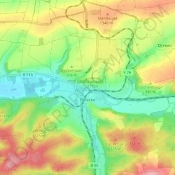
Name: Belecke topographic map, elevation, terrain.

Location: Belecke, Warstein, Kreis Soest, North Rhine-Westphalia, Germany (51.46486 8.30020 51.51370 8.37377)

Average elevation: 307 m

Minimum elevation: 243 m

Maximum elevation: 386 m

Other topographic maps

Click on a map to view its topography, its elevation and its terrain.

Wester

Germany > North Rhine-Westphalia > Kreis Soest > Warstein > Belecke

Average elevation: 308 m

Gear up for your next adventure:

🧦Merino Wool Socks - Moisture-wicking comfort for long-distance hiking
🧦Crew Hiking Socks - Comfortable socks for long-distance hikes
🛶Kayak Dry Bag - Waterproof storage for kayaking adventures
💡LED Camping Lantern - Illuminate your campsite with long-lasting lanterns
🧦Hiking Liner Socks - Thin base layer to prevent friction and blisters

As an Amazon Associate, this site earns from qualifying purchases at no extra cost to you.