Geolocate

Dingboche topographic map

Click on the map to display elevation.

Dingboche

Dingboche is a Sherpa village at an elevation of 4,410 m (14,470 ft) in the Khumbu region of northeastern Nepal. Its population was estimated at approximately 200 in 2011.

Wikipedia (CC-BY-SA 3.0)

About this map

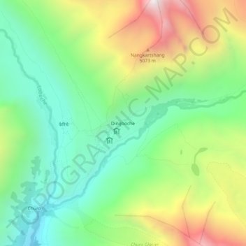
Name: Dingboche topographic map, elevation, terrain.

Location: Dingboche, Khumbupasanglahmu-04, Khumbupasanglahmu, Solukhumbu, Koshi Province, Nepal (27.87352 86.81094 27.91352 86.85094)

Average elevation: 4,600 m

Minimum elevation: 4,084 m

Maximum elevation: 5,482 m

Other topographic maps

Click on a map to view its topography, its elevation and its terrain.

Sotang

Nepal > Koshi Province > Solukhumbu

Average elevation: 2,173 m

West Ridge

Nepal > Koshi Province > Solukhumbu

Average elevation: 7,035 m

Likhupike

Nepal > Koshi Province > Solukhumbu

Average elevation: 2,755 m

Khumbupasanglahmu-05

Nepal > Koshi Province > Solukhumbu

Average elevation: 5,232 m

Gear up for your next adventure:

🧥Ultralight Puffy Jacket - Maximum warmth that packs down to the size of an orange
🥾Waterproof Trail Shoes - Shoes designed to handle wet terrain
🧥Thermal Layer - Insulating layer for cold outdoor conditions
🌡️Emergency Mylar Blankets - Compact thermal protection for unexpected nights outdoors
🚑Survival Whistle - Signal for help across long distances in mountains

As an Amazon Associate, this site earns from qualifying purchases at no extra cost to you.