Geolocate

Goldkronach topographic map

Click on the map to display elevation.

About this map

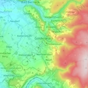
Name: Goldkronach topographic map, elevation, terrain.

Location: Goldkronach, Landkreis Bayreuth, Bavaria, 95497, Germany (49.97097 11.64089 50.02825 11.74379)

Average elevation: 518 m

Minimum elevation: 362 m

Maximum elevation: 810 m

Other topographic maps

Click on a map to view its topography, its elevation and its terrain.

Reizendorf

Germany > Bavaria > Landkreis Bayreuth > Ahorntal

Average elevation: 435 m

Pfarrhügel

Germany > Bavaria > Landkreis Bayreuth > Eckersdorf

Average elevation: 507 m

Spies

Germany > Bavaria > Landkreis Bayreuth > Betzenstein

Average elevation: 534 m

Gottelhof

Germany > Bavaria > Landkreis Bayreuth > Hollfeld

Average elevation: 407 m

Meinberg

Germany > Bavaria > Landkreis Bayreuth > Goldkronach

Average elevation: 450 m

Röhrig

Germany > Bavaria > Landkreis Bayreuth > Bindlacher Berg

Average elevation: 410 m

Gear up for your next adventure:

🛶Canoe Life Vest - Safety vest for water sports
👟Trail Running Shoes - Agile footwear for fast-paced topographic exploration
🛶Kayak Accessories - Essential gear for safe and fun kayaking adventures
👟Leg Gaiters - Keep debris, mud, and snow out of your boots
🧥Waterproof Jacket - Lightweight rain jackets for hiking and outdoor activities

As an Amazon Associate, this site earns from qualifying purchases at no extra cost to you.