
Make a donation
Gear up for your next adventure:
As an Amazon Associate, this site earns from qualifying purchases at no extra cost to you.
Hooversville topographic map
Click on the map to display elevation.
Make a donation
Gear up for your next adventure:
As an Amazon Associate, this site earns from qualifying purchases at no extra cost to you.
About this map
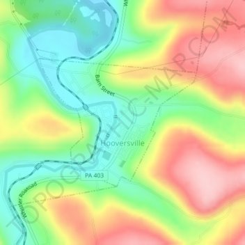
Name: Hooversville topographic map, elevation, terrain.
Location: Hooversville, Somerset County, Pennsylvania, United States (40.14223 -78.92395 40.15633 -78.90127)
Average elevation: 579 m
Minimum elevation: 497 m
Maximum elevation: 675 m
Make a donation
Gear up for your next adventure:
As an Amazon Associate, this site earns from qualifying purchases at no extra cost to you.
Other topographic maps
Click on a map to view its topography, its elevation and its terrain.
Mount Davis
United States > Pennsylvania > Somerset County > Elk Lick Township
Mount Davis has a humid continental climate that is affected by the high elevation significantly enough that the area feels slightly more like a cooler version of the climate zone during the winter months. Due to its high elevation, the area is colder much of the winter than Altoona, Johnstown, or State…
Average elevation: 908 m