Geolocate

Normandy topographic map

Click on the map to display elevation.

About this map

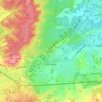
Name: Normandy topographic map, elevation, terrain.

Location: Normandy, Guildford, Surrey, England, United Kingdom (51.23527 -0.71216 51.28878 -0.63036)

Average elevation: 68 m

Minimum elevation: 31 m

Maximum elevation: 120 m

Other topographic maps

Click on a map to view its topography, its elevation and its terrain.

Wood Street

United Kingdom > England > Surrey > Guildford

Average elevation: 61 m

Gear up for your next adventure:

🔋Emergency Crank Radio - Weather alerts and power without needing batteries
🏃Hydration Running Vest - Carry water and maps close to your body for speed
Camping Essentials - All-in-one gear for a comfortable camping trip
🧥Waterproof Jacket - Lightweight rain jackets for hiking and outdoor activities
🧤Rechargeable Heated Gloves - Extreme warmth for Canadian winter expeditions

As an Amazon Associate, this site earns from qualifying purchases at no extra cost to you.