
Make a donation
Gear up for your next adventure:
As an Amazon Associate, this site earns from qualifying purchases at no extra cost to you.
Payson topographic map
Click on the map to display elevation.
Make a donation
Gear up for your next adventure:
As an Amazon Associate, this site earns from qualifying purchases at no extra cost to you.
Payson
Located in northern Gila County at an elevation of 5,000 feet (1,500 m), the town has a total area of 19.5 square miles (51 km2). The Mogollon Rim, the southern boundary of the Colorado Plateau, lies to the north of Payson, with elevations exceeding 7,500 feet (2,300 m); there are many cold water lakes on top of the rim. They are stocked with fish by the Arizona Game and Fish Department.
Make a donation
Gear up for your next adventure:
As an Amazon Associate, this site earns from qualifying purchases at no extra cost to you.
About this map
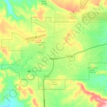
Name: Payson topographic map, elevation, terrain.
Location: Payson, Gila County, Arizona, 85072, United States (34.21706 -111.37054 34.27176 -111.27319)
Average elevation: 1,522 m
Minimum elevation: 1,379 m
Maximum elevation: 1,725 m
Make a donation
Gear up for your next adventure:
As an Amazon Associate, this site earns from qualifying purchases at no extra cost to you.