Geolocate

Osuna topographic map

Click on the map to display elevation.

About this map

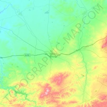
Name: Osuna topographic map, elevation, terrain.

Location: Osuna, Sevilla, Andalusia, 41640, Spain (37.08156 -5.27521 37.39253 -4.96586)

Average elevation: 291 m

Minimum elevation: 114 m

Maximum elevation: 788 m

Other topographic maps

Click on a map to view its topography, its elevation and its terrain.

Sierra de Castril

Spain > Andalusia > Comarca de Huéscar > Castril

Average elevation: 1,488 m

Isla Palma

Spain > Andalusia > Granada > Pinos Puente

Average elevation: 554 m

Gear up for your next adventure:

🧢Hiking Hat - Sun-protective and breathable hats for long treks
🧭GPS Handheld Device - Reliable GPS navigation for outdoor adventures
🧥Thermal Fleece Jacket - Versatile insulation for changing mountain temperatures
🧥Insulated Jacket - Keep warm in cold outdoor conditions
🚲Handlebar Phone Mount - View topographic-map.com live while cycling

As an Amazon Associate, this site earns from qualifying purchases at no extra cost to you.