Geolocate

El Paso topographic map

Click on the map to display elevation.

About this map

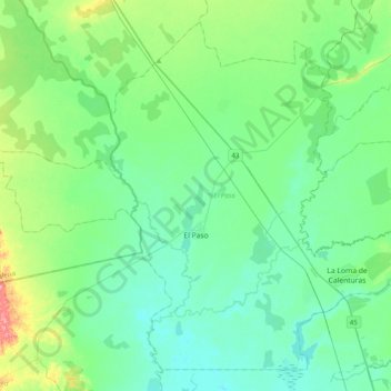
Name: El Paso topographic map, elevation, terrain.

Location: El Paso, Cesar, Colombia (9.52463 -73.83699 9.87288 -73.44129)

Average elevation: 47 m

Minimum elevation: 26 m

Maximum elevation: 84 m

Other topographic maps

Click on a map to view its topography, its elevation and its terrain.

Zapatosa

Colombia > Cesar > Tamalameque

Average elevation: 34 m

34

Colombia > Cesar > Perímetro Urbano Valledupar

Average elevation: 162 m

30

Colombia > Cesar > Perímetro Urbano Valledupar

Average elevation: 164 m

9

Colombia > Cesar > Perímetro Urbano Valledupar

Average elevation: 165 m

16

Colombia > Cesar > Perímetro Urbano Valledupar

Average elevation: 164 m

31

Colombia > Cesar > Perímetro Urbano Valledupar

Average elevation: 168 m

33

Colombia > Cesar > Perímetro Urbano Valledupar

Average elevation: 163 m

Gear up for your next adventure:

🧰Multitool Knife - Compact and versatile tool for outdoor use
🥾Waterproof Hiking Boots - Boots keeping your feet dry in wet conditions
🔋Solar Power Bank - Keep your GPS and devices charged during long outdoor trips
💧Filtered Water Bottle - Safe drinking water on the go
🎒Hiking Daypack - Lightweight and durable backpacks for day trips and excursions

As an Amazon Associate, this site earns from qualifying purchases at no extra cost to you.