Geolocate

Taplow topographic map

Click on the map to display elevation.

About this map

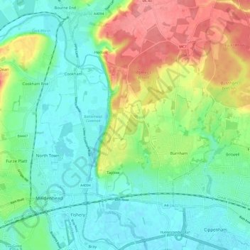
Name: Taplow topographic map, elevation, terrain.

Location: Taplow, Buckinghamshire, England, United Kingdom (51.50717 -0.70360 51.58214 -0.65328)

Average elevation: 48 m

Minimum elevation: 20 m

Maximum elevation: 104 m

Gear up for your next adventure:

🛶Kayak Dry Bag - Waterproof storage for kayaking adventures
🧼Biodegradable Camp Soap - Environmentally friendly cleaning for gear and body
🛌Down Sleeping Bag - Superior warmth-to-weight ratio for cold nights
🥾Trail Running Boots - Durable shoes designed for trail running
🥾Waterproof Hiking Shoes - Durable shoes for wet and rugged trails

As an Amazon Associate, this site earns from qualifying purchases at no extra cost to you.