Geolocate

Tarragona topographic map

Click on the map to display elevation.

About this map

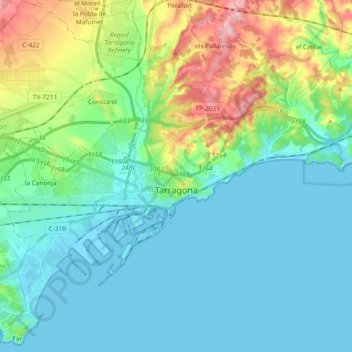
Name: Tarragona topographic map, elevation, terrain.

Location: Tarragona, Tarragonès, Tarragona, Catalonia, Spain (41.07864 1.18706 41.16688 1.37520)

Average elevation: 41 m

Minimum elevation: -5 m

Maximum elevation: 177 m

Other topographic maps

Click on a map to view its topography, its elevation and its terrain.

Salou

Spain > Catalonia > Tarragonès > Salou > Salou

Average elevation: 15 m

Parc del Fòrum

Spain > Catalonia > Tarragonès > Tarragona

Average elevation: 20 m

Gear up for your next adventure:

🧢Outdoor Visor - Breathable visor for sunny hikes
🩹Moleskin Blister Pads - Direct protection for painful foot pressure points
Tent Footprint - Protect tent floor and increase durability
🔋Solar Power Bank - Keep your GPS and devices charged during long outdoor trips
🛏️Camping Sleeping Mat - Comfortable mats for sleeping outdoors

As an Amazon Associate, this site earns from qualifying purchases at no extra cost to you.