
Make a donation
Gear up for your next adventure:
As an Amazon Associate, this site earns from qualifying purchases at no extra cost to you.
Philadelphia topographic map
Click on the map to display elevation.
Make a donation
Gear up for your next adventure:
As an Amazon Associate, this site earns from qualifying purchases at no extra cost to you.
About this map
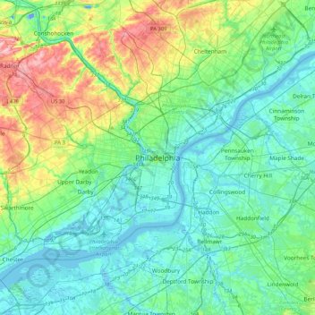
Name: Philadelphia topographic map, elevation, terrain.
Average elevation: 35 m
Minimum elevation: -18 m
Maximum elevation: 155 m
Make a donation
Gear up for your next adventure:
As an Amazon Associate, this site earns from qualifying purchases at no extra cost to you.
Other topographic maps
Click on a map to view its topography, its elevation and its terrain.
East Falls
United States > Pennsylvania > Philadelphia County > Philadelphia
East Falls takes its name from its location on the east side of the Schuylkill Falls along the Schuylkill River at the original line of waterfalls known as the 'Falls of the Schuylkill' where the river descends from the elevation of the Pennsylvania piedmont to the coastal plain occupied by the main part of…
Average elevation: 54 m