Geolocate

Woking topographic map

Click on the map to display elevation.

About this map

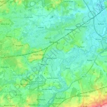
Name: Woking topographic map, elevation, terrain.

Location: Woking, Surrey, England, United Kingdom (51.26549 -0.64998 51.34963 -0.46099)

Average elevation: 38 m

Minimum elevation: 12 m

Maximum elevation: 138 m

Other topographic maps

Click on a map to view its topography, its elevation and its terrain.

Bagshot

United Kingdom > England > Surrey > Surrey Heath

Average elevation: 80 m

Penelopes Pond

United Kingdom > England > Surrey > Waverley > Milford

Average elevation: 59 m

Weybridge

United Kingdom > England > Surrey > Elmbridge

Average elevation: 21 m

Redhill

United Kingdom > England > Surrey > Reigate and Banstead

To the north, the town joins with the village of Merstham, north of which there is a "wind gap" in the chalk hills of the North Downs, at an elevation of 120 metres (390 feet) above sea level, through which the A23 road heads in from London. Geologists have speculated that there may once have been a…

Average elevation: 107 m

North Bourne

United Kingdom > England > Surrey > Surrey Heath > Chobham

Average elevation: 33 m

Bishopsgate

United Kingdom > England > Surrey > Runnymede > Bishopsgate

Average elevation: 50 m

Ewell

United Kingdom > England > Surrey > Epsom and Ewell

Average elevation: 49 m

Wood Street

United Kingdom > England > Surrey > Guildford

Average elevation: 61 m

Gear up for your next adventure:

🧤Thermal Hiking Gloves - Grip-enhanced gloves for cold-weather altitude trekking
🥤Collapsible Travel Cup - Saves space and weight in your mess kit
🥾Lightweight Hiking Boots - Boots for comfort and mobility on long hikes
🧰Survival Kit - Essential gear for emergencies in the wilderness
👟Leg Gaiters - Keep debris, mud, and snow out of your boots

As an Amazon Associate, this site earns from qualifying purchases at no extra cost to you.