
Make a donation
Gear up for your next adventure:
As an Amazon Associate, this site earns from qualifying purchases at no extra cost to you.
Isfahan topographic map
Click on the map to display elevation.
Make a donation
Gear up for your next adventure:
As an Amazon Associate, this site earns from qualifying purchases at no extra cost to you.
Isfahan
Isfahan has a cold desert climate (Köppen: BWk), characterized by low annual precipitation, clear skies, strong sunlight, and large temperature fluctuations between day and night. The city, situated at an elevation of approximately 1,570 meters above sea level, experiences hot, dry summers and cool to cold winters, with most precipitation occurring between late autumn and early spring.
Make a donation
Gear up for your next adventure:
As an Amazon Associate, this site earns from qualifying purchases at no extra cost to you.
About this map
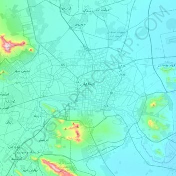
Name: Isfahan topographic map, elevation, terrain.
Average elevation: 1,607 m
Minimum elevation: 1,535 m
Maximum elevation: 2,469 m
Make a donation
Gear up for your next adventure:
As an Amazon Associate, this site earns from qualifying purchases at no extra cost to you.
Other topographic maps
Click on a map to view its topography, its elevation and its terrain.
Make a donation
Gear up for your next adventure:
As an Amazon Associate, this site earns from qualifying purchases at no extra cost to you.