Geolocate

Bad Muskau - Mužakow topographic map

Click on the map to display elevation.

About this map

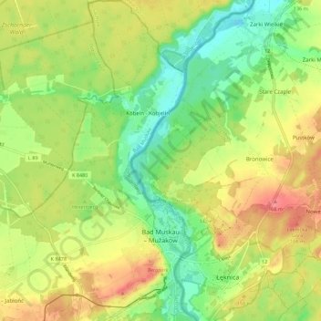
Name: Bad Muskau - Mužakow topographic map, elevation, terrain.

Location: Bad Muskau - Mužakow, Bad Muskau, Görlitz, Saxony, Germany (51.52883 14.67715 51.59724 14.73129)

Average elevation: 130 m

Minimum elevation: 93 m

Maximum elevation: 172 m

Gear up for your next adventure:

🛁Quick-Dry Microfiber Towel - Space-saving towel that dries rapidly on the move
💧Hydration Bladder - Hands-free hydration solution for long treks
Lightweight Camping Tent - Portable shelter optimized for Canadian backcountry camping
💡Solar Camping Lamp - Eco-friendly lighting for campsites
🥾Waterproof Hiking Boots - Essential footwear for rugged terrain and wet Canadian trails

As an Amazon Associate, this site earns from qualifying purchases at no extra cost to you.