
Civitanova Marche topographic map
Interactive map
Click on the map to display elevation.
About this map
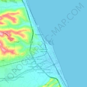
Name: Civitanova Marche topographic map, elevation, terrain.
Location: Civitanova Marche, Macerata, Marche, 62012, Italy (43.27484 13.62935 43.34920 13.74328)
Average elevation: 23 m
Minimum elevation: -3 m
Maximum elevation: 176 m
The area is 46,07 km2. The altitude ranges from 3 to 223 meters above sea level. The typical "a pettine" shape that distinguishes Marche hills is recognizable.