
Westlake topographic map
Interactive map
Click on the map to display elevation.
About this map
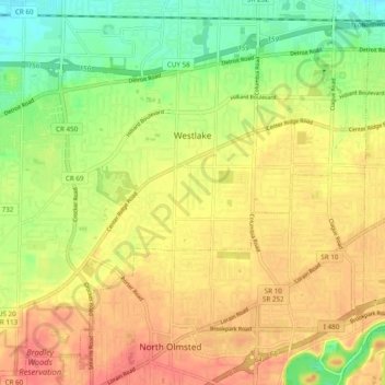
Name: Westlake topographic map, elevation, terrain.
Location: Westlake, Cuyahoga County, Ohio, 44145, United States (41.41105 -81.97026 41.47804 -81.87370)
Average elevation: 218 m
Minimum elevation: 188 m
Maximum elevation: 242 m
Other topographic maps
Click on a map to view its topography, its elevation and its terrain.
Cleveland Heights
United States > Ohio > Cuyahoga County
Cleveland Heights, Cuyahoga County, Ohio, 44118, United States
Average elevation: 276 m
Highland Heights
United States > Ohio > Cuyahoga County
Highland Heights, Cuyahoga County, Ohio, 44143, United States
Average elevation: 289 m
Cleveland
United States > Ohio > Cuyahoga County
Cleveland, Cuyahoga County, Ohio, United States
Average elevation: 215 m
Cleveland
United States > Ohio > Cuyahoga County > Cleveland
Cleveland, Cuyahoga County, Ohio, 44113, United States
Average elevation: 221 m
Bedford Heights
United States > Ohio > Cuyahoga County
Bedford Heights, Cuyahoga County, Ohio, United States
Average elevation: 310 m
Euclid
United States > Ohio > Cuyahoga County
Euclid, Cuyahoga County, Ohio, United States
Average elevation: 206 m