Geolocate

Markyate topographic map

Click on the map to display elevation.

About this map

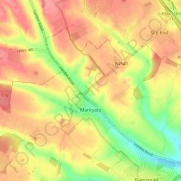
Name: Markyate topographic map, elevation, terrain.

Location: Markyate, Dacorum, Hertfordshire, England, United Kingdom (51.82541 -0.50342 51.85589 -0.43275)

Average elevation: 154 m

Minimum elevation: 110 m

Maximum elevation: 185 m

Gear up for your next adventure:

🧭GPS Handheld Device - Reliable GPS navigation for outdoor adventures
🥾Mountain Trail Shoes - High-traction shoes for mountain trails
🛌Down Sleeping Bag - Superior warmth-to-weight ratio for cold nights
🔨Vehicle Emergency Tool - Safety tool for remote road trips to trailheads
🧦Thermal Socks - Warm socks for winter hiking or camping

As an Amazon Associate, this site earns from qualifying purchases at no extra cost to you.