
Diran topographic map
Interactive map
Click on the map to display elevation.
About this map
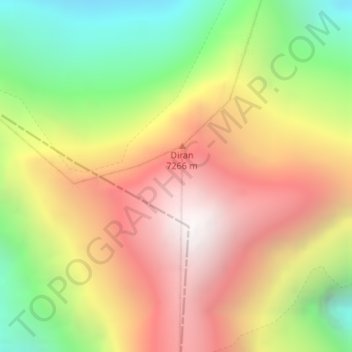
Name: Diran topographic map, elevation, terrain.
Location: Diran, Gilgit, Gilgit District, Gilgit-Baltistan, Pakistan (36.12463 74.65922 36.12473 74.65932)
Average elevation: 6,311 m
Minimum elevation: 5,324 m
Maximum elevation: 7,252 m
Other topographic maps
Click on a map to view its topography, its elevation and its terrain.
Rakaposhi
Pakistan > Gilgit-Baltistan > Gilgit
Rakaposhi, Gilgit, Gilgit District, Gilgit-Baltistan, Pakistan
Average elevation: 6,882 m
Gilgit
Pakistan > Gilgit-Baltistan > Gilgit
Gilgit, Gilgit District, Gilgit-Baltistan, Pakistan
Average elevation: 3,002 m