
Make a donation
Gear up for your next adventure:
As an Amazon Associate, this site earns from qualifying purchases at no extra cost to you.
Sucre topographic map
Click on the map to display elevation.
Make a donation
Gear up for your next adventure:
As an Amazon Associate, this site earns from qualifying purchases at no extra cost to you.
Sucre
Sucre (Spanish: [ˈsukɾe]) is the de jure capital city of Bolivia, the capital of the Chuquisaca Department and the sixth most populous city in Bolivia. Located in the south-central part of the country, Sucre lies at an elevation of 2,790 m (9,150 ft). This relatively high altitude gives the city a subtropical highland climate with cool temperatures year-round. Over the centuries, the city has received various names, including La Plata, Charcas, and Chuquisaca. Today, the region is of predominantly Quechua background, with some Aymara communities and influences.
Make a donation
Gear up for your next adventure:
As an Amazon Associate, this site earns from qualifying purchases at no extra cost to you.
About this map
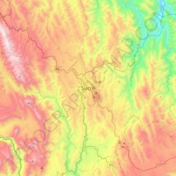
Name: Sucre topographic map, elevation, terrain.
Average elevation: 2,829 m
Minimum elevation: 1,882 m
Maximum elevation: 3,846 m
Make a donation
Gear up for your next adventure:
As an Amazon Associate, this site earns from qualifying purchases at no extra cost to you.
Other topographic maps
Click on a map to view its topography, its elevation and its terrain.