
Make a donation
Gear up for your next adventure:
As an Amazon Associate, this site earns from qualifying purchases at no extra cost to you.
Kirchbach topographic map
Click on the map to display elevation.
Make a donation
Gear up for your next adventure:
As an Amazon Associate, this site earns from qualifying purchases at no extra cost to you.
About this map
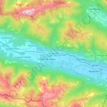
Name: Kirchbach topographic map, elevation, terrain.
Location: Kirchbach, Bezirk Hermagor, Carinthia, Austria (46.58710 13.08438 46.69395 13.25495)
Average elevation: 1,180 m
Minimum elevation: 592 m
Maximum elevation: 2,355 m
Make a donation
Gear up for your next adventure:
As an Amazon Associate, this site earns from qualifying purchases at no extra cost to you.
Other topographic maps
Click on a map to view its topography, its elevation and its terrain.
Obermöschach
Austria > Carinthia > Bezirk Hermagor > Hermagor-Pressegger See > Hermagor
Average elevation: 765 m
Gartnerkofel
Austria > Carinthia > Bezirk Hermagor > Hermagor-Pressegger See
Average elevation: 1,705 m
Make a donation
Gear up for your next adventure:
As an Amazon Associate, this site earns from qualifying purchases at no extra cost to you.
Lake Pressegg
Austria > Carinthia > Bezirk Hermagor > Hermagor-Pressegger See > Presseggersee > Paßriach
Average elevation: 627 m
Nassfeldpass / Passo di Pramollo
Austria > Carinthia > Bezirk Hermagor > Hermagor-Pressegger See > Sonnenalpe Naßfeld
Average elevation: 1,572 m
Make a donation
Gear up for your next adventure:
As an Amazon Associate, this site earns from qualifying purchases at no extra cost to you.