
Brattleboro topographic map
Click on the map to display elevation.
Brattleboro
The town's densely populated center is located near Vermont's lowest elevation point in the Connecticut river valley. Because of the surrounding steep hills there is very little flat land, and many of its buildings and houses are situated on steep hillsides, necessarily closely bunched together. This concentrated topography and population density have helped to create a semi-urban, cosmopolitan atmosphere in the downtown.
About this map
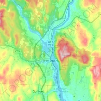
Name: Brattleboro topographic map, elevation, terrain.
Location: Brattleboro, Windham County, Vermont, 05301, United States (42.82400 -72.68063 42.89966 -72.53225)
Average elevation: 184 m
Minimum elevation: 60 m
Maximum elevation: 412 m