
Make a donation
Gear up for your next adventure:
As an Amazon Associate, this site earns from qualifying purchases at no extra cost to you.
Red Bluff topographic map
Click on the map to display elevation.
Make a donation
Gear up for your next adventure:
As an Amazon Associate, this site earns from qualifying purchases at no extra cost to you.
About this map
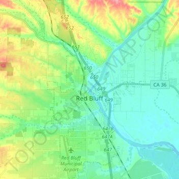
Name: Red Bluff topographic map, elevation, terrain.
Location: Red Bluff, Tehama County, California, 96080, United States (40.13510 -122.26641 40.23084 -122.19682)
Average elevation: 103 m
Minimum elevation: 74 m
Maximum elevation: 176 m
Make a donation
Gear up for your next adventure:
As an Amazon Associate, this site earns from qualifying purchases at no extra cost to you.
Other topographic maps
Click on a map to view its topography, its elevation and its terrain.
Gerber
United States > California > Tehama County
Gerber is a census-designated place (CDP) in Tehama County, California. Gerber sits at an elevation of 226 feet (69 m). The 2020 United States census reported Gerber's population was 1,044.
Average elevation: 72 m
Make a donation
Gear up for your next adventure:
As an Amazon Associate, this site earns from qualifying purchases at no extra cost to you.