Geolocate

Madera topographic map

Click on the map to display elevation.

About this map

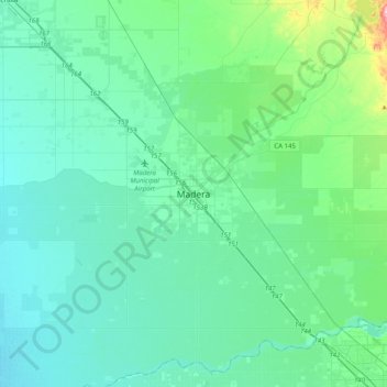
Name: Madera topographic map, elevation, terrain.

Location: Madera, Madera County, California, 93637, United States (36.80227 -120.21947 37.12227 -119.89947)

Average elevation: 87 m

Minimum elevation: 52 m

Maximum elevation: 306 m

Gear up for your next adventure:

🛌Insulated Sleeping Pad - Critical thermal barrier between you and the cold ground
💡Portable Camping Lamp - Rechargeable lamp for campsite lighting
🥾Trail Running Boots - Durable shoes designed for trail running
Family Camping Tent - Spacious tent suitable for family camping trips
🧣Merino Neck Gaiter - Protects against wind, sun, and cold at high altitudes

As an Amazon Associate, this site earns from qualifying purchases at no extra cost to you.