Geolocate

Vadakara topographic map

Click on the map to display elevation.

About this map

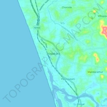
Name: Vadakara topographic map, elevation, terrain.

Location: Vadakara, Kozhikode district, Kerala, 670109, India (11.55707 75.55037 11.63707 75.63037)

Average elevation: 12 m

Minimum elevation: -3 m

Maximum elevation: 121 m

Other topographic maps

Click on a map to view its topography, its elevation and its terrain.

Vadakara

India > Kerala > Vadakara

Average elevation: 186 m

Gear up for your next adventure:

🛶Waterproof Dry Bags - Keep electronics and clothes dry during river crossings
🛌Insulated Sleeping Pad - Critical thermal barrier between you and the cold ground
🧥Waterproof Pants - Keep dry during rainy hiking conditions
💧Filtered Water Bottle - Safe drinking water on the go
🪑Insulated Seat Pad - Protect your seat from cold rocks and wet logs

As an Amazon Associate, this site earns from qualifying purchases at no extra cost to you.