
Make a donation
Gear up for your next adventure:
As an Amazon Associate, this site earns from qualifying purchases at no extra cost to you.
Apaña topographic map
Click on the map to display elevation.
Make a donation
Gear up for your next adventure:
As an Amazon Associate, this site earns from qualifying purchases at no extra cost to you.
About this map
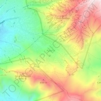
Name: Apaña topographic map, elevation, terrain.
Location: Apaña, Palca, Pedro Domingo Murillo, La Paz, Bolivia (-16.56680 -68.04368 -16.52680 -68.00368)
Average elevation: 3,924 m
Minimum elevation: 3,574 m
Maximum elevation: 4,332 m
Make a donation
Gear up for your next adventure:
As an Amazon Associate, this site earns from qualifying purchases at no extra cost to you.
Other topographic maps
Click on a map to view its topography, its elevation and its terrain.
La Paz
Bolivia > La Paz > Pedro Domingo Murillo
The city, in west-central Bolivia 68 km (42 mi) southeast of Lake Titicaca, is set in a canyon created by the Choqueyapu River. It is in a bowl-like depression, part of the Amazon basin, surrounded by the high mountains of the Altiplano. Overlooking the city is the towering, triple-peaked Illimani. Its peaks…
Average elevation: 3,544 m
Make a donation
Gear up for your next adventure:
As an Amazon Associate, this site earns from qualifying purchases at no extra cost to you.
Mecapaca
Bolivia > La Paz > Pedro Domingo Murillo
Mecapaca Municipality is the second municipal section of the Pedro Domingo Murillo Province in the La Paz Department, Bolivia. Its seat is Mecapaca. It is situated 28 km from the city of La Paz, the capital of the department and the seat of government for the country, and it stands at an elevation of 2,850…
Average elevation: 3,684 m
Make a donation
Gear up for your next adventure:
As an Amazon Associate, this site earns from qualifying purchases at no extra cost to you.
Make a donation
Gear up for your next adventure:
As an Amazon Associate, this site earns from qualifying purchases at no extra cost to you.
La Paz
Bolivia > La Paz > Pedro Domingo Murillo
Located in west-central Bolivia 68 km (42 mi) southeast of Lake Titicaca, La Paz is set in a canyon created by the Choqueyapu River. It is in a bowl-like depression, part of the Amazon basin, surrounded by the high mountains of the Altiplano. Overlooking the city is the triple-peaked Illimani. Its peaks are…
Average elevation: 3,544 m
Make a donation
Gear up for your next adventure:
As an Amazon Associate, this site earns from qualifying purchases at no extra cost to you.
La Paz
Bolivia > La Paz > Pedro Domingo Murillo
The city, in west-central Bolivia 68 km (42 mi) southeast of Lake Titicaca, is set in a canyon created by the Choqueyapu River. It is in a bowl-like depression, part of the Amazon basin, surrounded by the high mountains of the Altiplano. Overlooking the city is the triple-peaked Illimani. Its peaks are always…
Average elevation: 3,544 m
Make a donation
Gear up for your next adventure:
As an Amazon Associate, this site earns from qualifying purchases at no extra cost to you.
La Paz
Bolivia > La Paz > Pedro Domingo Murillo
Located in west-central Bolivia 68 km (42 mi) southeast of Lake Titicaca, La Paz is set in a canyon created by the Choqueyapu River. It is in a bowl-like depression, part of the Amazon basin, surrounded by the high mountains of the Altiplano. Overlooking the city is the triple-peaked Illimani. Its peaks are…
Average elevation: 3,544 m
Make a donation
Gear up for your next adventure:
As an Amazon Associate, this site earns from qualifying purchases at no extra cost to you.
La Paz
Bolivia > La Paz > Pedro Domingo Murillo
Located in west-central Bolivia 68 km (42 mi) southeast of Lake Titicaca, La Paz is set in a canyon created by the Choqueyapu River. It is in a bowl-like depression, part of the Amazon basin, surrounded by the high mountains of the Altiplano. Overlooking the city is the triple-peaked Illimani. Its peaks are…
Average elevation: 3,544 m
Make a donation
Gear up for your next adventure:
As an Amazon Associate, this site earns from qualifying purchases at no extra cost to you.
Make a donation
Gear up for your next adventure:
As an Amazon Associate, this site earns from qualifying purchases at no extra cost to you.