
Make a donation
Gear up for your next adventure:
As an Amazon Associate, this site earns from qualifying purchases at no extra cost to you.
Russell topographic map
Click on the map to display elevation.
Make a donation
Gear up for your next adventure:
As an Amazon Associate, this site earns from qualifying purchases at no extra cost to you.
Russell
The town has two very different sections: South Quarter is mainly uplands at elevations from 1,000 to 1,400 feet (300 to 430 m) along the rim of a plateau west of the Connecticut River Valley, while the rest of the town is a deep valley along the swift Westfield River.
Make a donation
Gear up for your next adventure:
As an Amazon Associate, this site earns from qualifying purchases at no extra cost to you.
About this map
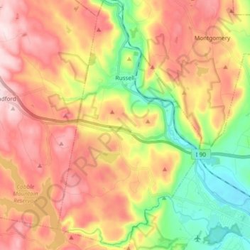
Name: Russell topographic map, elevation, terrain.
Location: Russell, Hampden County, Massachusetts, United States (42.11500 -72.89566 42.22366 -72.81091)
Average elevation: 256 m
Minimum elevation: 43 m
Maximum elevation: 458 m
Make a donation
Gear up for your next adventure:
As an Amazon Associate, this site earns from qualifying purchases at no extra cost to you.
Other topographic maps
Click on a map to view its topography, its elevation and its terrain.
South End
United States > Massachusetts > Hampden County > Springfield > South End
Average elevation: 37 m