Geolocate

Dombivli topographic map

Click on the map to display elevation.

Dombivli

Dombivli is located at 19°13′06″N 73°05′12″E / 19.218433°N 73.086718°E / 19.218433; 73.086718. It has an average elevation of 13.534 meters (44.403 feet). The land here is rough and rocky by nature. The Ulhas river flows from its north. The Arabian sea is about 50 km west from Dombivli.

Wikipedia (CC-BY-SA 3.0)

About this map

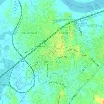
Name: Dombivli topographic map, elevation, terrain.

Location: Dombivli, Kalyan-Dombivli, Kalyan Taluka, Thane, Maharashtra, 421201, India (19.19486 73.07103 19.23486 73.11103)

Average elevation: 11 m

Minimum elevation: 0 m

Maximum elevation: 39 m

Gear up for your next adventure:

🥾Mountain Hiking Shoes - Shoes with superior grip for mountainous terrain
🥾Trail Running Shoes - Lightweight and durable shoes for trail running
🧥Thermal Layer - Insulating layer for cold outdoor conditions
🥾Mountain Hiking Boots - High-traction boots for rocky terrain
🧥Softshell Hiking Jacket - The perfect balance of wind protection and breathability

As an Amazon Associate, this site earns from qualifying purchases at no extra cost to you.