
Make a donation
Gear up for your next adventure:
As an Amazon Associate, this site earns from qualifying purchases at no extra cost to you.
Ardennes topographic map
Click on the map to display elevation.
Make a donation
Gear up for your next adventure:
As an Amazon Associate, this site earns from qualifying purchases at no extra cost to you.
Ardennes
Covering 5,229 square kilometres (2,019 square miles), the department was the smallest among the four contributors to Champagne-Ardenne. It is diverse in climate, topography, natural vegetation and land use, which is a mixture of forest and arable farming.
Make a donation
Gear up for your next adventure:
As an Amazon Associate, this site earns from qualifying purchases at no extra cost to you.
About this map
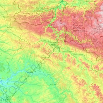
Name: Ardennes topographic map, elevation, terrain.
Location: Ardennes, Grand Est, Metropolitan France, France (49.22685 4.02460 50.16932 5.39407)
Average elevation: 225 m
Minimum elevation: 55 m
Maximum elevation: 574 m
Make a donation
Gear up for your next adventure:
As an Amazon Associate, this site earns from qualifying purchases at no extra cost to you.