Geolocate

Mount Batolusong topographic map

Click on the map to display elevation.

About this map

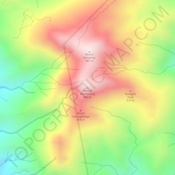
Name: Mount Batolusong topographic map, elevation, terrain.

Location: Mount Batolusong, Rizal, Calabarzon, Philippines (14.63923 121.31506 14.63933 121.31516)

Average elevation: 675 m

Minimum elevation: 378 m

Maximum elevation: 933 m

Other topographic maps

Click on a map to view its topography, its elevation and its terrain.

Cainta

Philippines > Rizal

Average elevation: 33 m

Gear up for your next adventure:

🥾Mountain Hiking Shoes - Shoes with superior grip for mountainous terrain
🧢Outdoor Cap - Protective cap for sun and rain during hikes
🥾Mountain Hiking Boots - High-traction boots for rocky terrain
🛌Insulated Sleeping Pad - Critical thermal barrier between you and the cold ground
🔨Vehicle Emergency Tool - Safety tool for remote road trips to trailheads

As an Amazon Associate, this site earns from qualifying purchases at no extra cost to you.