Geolocate

Hanover topographic map

Click on the map to display elevation.

About this map

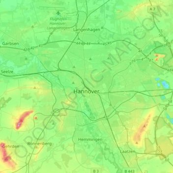
Name: Hanover topographic map, elevation, terrain.

Location: Hanover, Region Hannover, Lower Saxony, Germany (52.30514 9.60443 52.45433 9.91843)

Average elevation: 61 m

Minimum elevation: 21 m

Maximum elevation: 168 m

Other topographic maps

Click on a map to view its topography, its elevation and its terrain.

Scherenbostel

Germany > Lower Saxony > Region Hannover

Average elevation: 60 m

Altwarmbüchen

Germany > Lower Saxony > Region Hannover

Average elevation: 57 m

Dachtmissen

Germany > Lower Saxony > Region Hannover > Burgdorf

Average elevation: 53 m

Resse

Germany > Lower Saxony > Region Hannover

Average elevation: 48 m

Kirchhorst

Germany > Lower Saxony > Region Hannover

Average elevation: 60 m

Liethe

Germany > Lower Saxony > Region Hannover > Wunstorf

Average elevation: 46 m

Gear up for your next adventure:

🚲Bike Repair Kit - Essential tools for on-trail mechanical issues
🔭Compact Binoculars - Lightweight optics for scouting trails and wildlife
Lightweight Backpacking Tent - Compact tent for efficient hiking trips
🧰Emergency Multi-Tool - Compact multi-tool for outdoor survival
🕶️Polarized Sunglasses - Reduces glare from snow and water at high elevations

As an Amazon Associate, this site earns from qualifying purchases at no extra cost to you.