
Make a donation
Gear up for your next adventure:
As an Amazon Associate, this site earns from qualifying purchases at no extra cost to you.
Cobán topographic map
Click on the map to display elevation.
Make a donation
Gear up for your next adventure:
As an Amazon Associate, this site earns from qualifying purchases at no extra cost to you.
Cobán
As of the 2018 census, the population of the city of Cobán was 212,047 and that of the municipality was 212,421. Cobán lies at an altitude of 1,320 metres or 4,330 feet above sea level and covers a total area of 1,974 km2. It is located at the center of a major coffee-growing area.
Make a donation
Gear up for your next adventure:
As an Amazon Associate, this site earns from qualifying purchases at no extra cost to you.
About this map
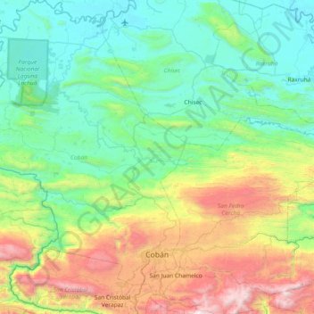
Name: Cobán topographic map, elevation, terrain.
Location: Cobán, Zona 12, Alta Verapaz, Guatemala (15.33579 -90.82069 16.04176 -90.28178)
Average elevation: 734 m
Minimum elevation: 118 m
Maximum elevation: 2,612 m
Make a donation
Gear up for your next adventure:
As an Amazon Associate, this site earns from qualifying purchases at no extra cost to you.
Other topographic maps
Click on a map to view its topography, its elevation and its terrain.