Geolocate

Moncheaux topographic map

Click on the map to display elevation.

About this map
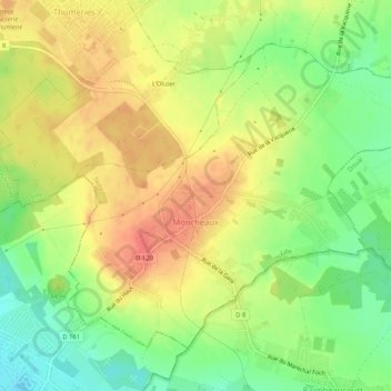
Name: Moncheaux topographic map, elevation, terrain.

Location: Moncheaux, Lille, Nord, Hauts-de-France, Metropolitan France, 59283, France (50.44397 3.06551 50.46981 3.11760)

Average elevation: 53 m

Minimum elevation: 25 m

Maximum elevation: 77 m

Other topographic maps

Click on a map to view its topography, its elevation and its terrain.
Arenberg

France > Hauts-de-France > Nord > Wallers

Average elevation: 31 m

Mouvaux

France > Hauts-de-France > Nord > Mouvaux > Mouvaux

Average elevation: 35 m

Gear up for your next adventure:

🥾Mountain Hiking Shoes - Shoes with superior grip for mountainous terrain
🧥Thermal Layer - Insulating layer for cold outdoor conditions
🔦LED Headlamp - Hands-free lighting for early morning starts or late finishes
🧢Outdoor Cap - Protective cap for sun and rain during hikes
🥾Waterproof Hiking Boots - Boots keeping your feet dry in wet conditions

As an Amazon Associate, this site earns from qualifying purchases at no extra cost to you.