Geolocate

Clinton Township topographic map

Click on the map to display elevation.

About this map

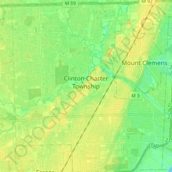
Name: Clinton Township topographic map, elevation, terrain.

Location: Clinton Township, Macomb County, Michigan, United States (42.53933 -82.97331 42.63021 -82.85571)

Average elevation: 184 m

Minimum elevation: 173 m

Maximum elevation: 193 m

Other topographic maps

Click on a map to view its topography, its elevation and its terrain.

Gear up for your next adventure:

🔋Lithium AA Batteries - Long-lasting power that performs in extreme cold
🕯️Camping Lantern - Illuminates your entire campsite with high-efficiency LEDs
🧥Ultralight Puffy Jacket - Maximum warmth that packs down to the size of an orange
🧊Insulated Water Bottle - Keeps drinks cold in summer and prevents freezing in winter
🕶️Polarized Sunglasses - Protect your eyes with durable polarized lenses

As an Amazon Associate, this site earns from qualifying purchases at no extra cost to you.