Geolocate

Drasco topographic map

Click on the map to display elevation.

About this map

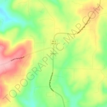
Name: Drasco topographic map, elevation, terrain.

Location: Drasco, Cleburne County, Arkansas, 72530, United States (35.61147 -91.96709 35.65147 -91.92709)

Average elevation: 309 m

Minimum elevation: 234 m

Maximum elevation: 385 m

Other topographic maps

Click on a map to view its topography, its elevation and its terrain.

Greers Ferry

United States > Arkansas > Cleburne County

Average elevation: 162 m

Gear up for your next adventure:

🏕️Camping Hammock - Integrated protection for sleeping between trees
🥾Trekking Poles - Adjustable trekking poles to reduce knee stress and improve stability
🥾Mountaineering Boots - Supportive boots for climbing and high-altitude hiking
🔦LED Headtorch - Bright and durable light for night activities
🦶Hiking Shoe Insoles - Added support for high arches and long days on feet

As an Amazon Associate, this site earns from qualifying purchases at no extra cost to you.