
Make a donation
Gear up for your next adventure:
As an Amazon Associate, this site earns from qualifying purchases at no extra cost to you.
Reichenbach-Steegen topographic map
Click on the map to display elevation.
Make a donation
Gear up for your next adventure:
As an Amazon Associate, this site earns from qualifying purchases at no extra cost to you.
About this map
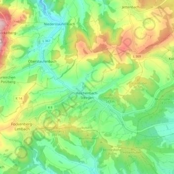
Name: Reichenbach-Steegen topographic map, elevation, terrain.
Average elevation: 336 m
Minimum elevation: 233 m
Maximum elevation: 512 m
Make a donation
Gear up for your next adventure:
As an Amazon Associate, this site earns from qualifying purchases at no extra cost to you.
Other topographic maps
Click on a map to view its topography, its elevation and its terrain.
Air Base
Germany > Rhineland-Palatinate > Landkreis Kaiserslautern > Ramstein-Miesenbach
Average elevation: 237 m
Eulenbis
Germany > Rhineland-Palatinate > Landkreis Kaiserslautern > Eulenbis > Eulenbis
Average elevation: 303 m
Burg Nanstein
Germany > Rhineland-Palatinate > Landkreis Kaiserslautern > Landstuhl
Average elevation: 303 m
Make a donation
Gear up for your next adventure:
As an Amazon Associate, this site earns from qualifying purchases at no extra cost to you.